Sunday, October 30, 2011

Shifting Perspectives at Don Edwards National Wildlife Refuge

If I told you it was beautiful upon first sight, I’d be lying. The landscape is a flat patchwork of open water, barren soil, and dense tule marshes ringed by industrial development. But if I told you it was unique, there isn’t a doubt in my mind you’d agree. Exiting the highway just east of San Jose, you meander from traffic clogged thoroughfares to the neighborhood streets of the incorporated town of Alviso where houses are built on stilts and one street corner has been designated the community sandbagging lot, a sure sign there must be water somewhere. Finally, you turn onto a poorly paved road that takes off across the scrub land as if intending to lead you on a wild goose chase. But just at the edge of the open expanse of the South Bay you come to it – Don Edwards National Wildlife Refuge, the nation’s first federally protected urban refuge for wetland plants and animals.

The wooden headquarters building has the feel of a well fortified tree house with its massive dark beams and narrow spiraling staircase leading up level by shrinking level to a tiny lookout at the very top with windows on three sides. From this vantage point, you can see the refuge, surrounding urban landscape and indeed the entire Bay Area stretched out before you. Coming and going across the sky are dozens of birds in all shapes and sizes. More flocks are scattered across the salty ground and in the large shallow pools. Their mere presence invites you down from the tower to come out and take a closer look.

This habitat has been drastically altered by human beings for over a century through building levees for flood control and the conversion of marshland into salt ponds used to harvest the culinary staple. The newly restored one hundred acre LaRiviere Marsh behind the visitor center shows the next phase of human impact on the landscape here. A wooden boardwalk snakes from the visitor center out into the wetland where sinuous creeks trace through the undulating mounds of silt and picklweed. Northern shovelers float peacefully among the reeds while sandpipers flit across the muddy banks chasing insects. This land was regraded to mimic the original topography and the levee was breached to reintroduce tidal flows from the bay. All that remains to be done now is observe and learn as the bay does its work.

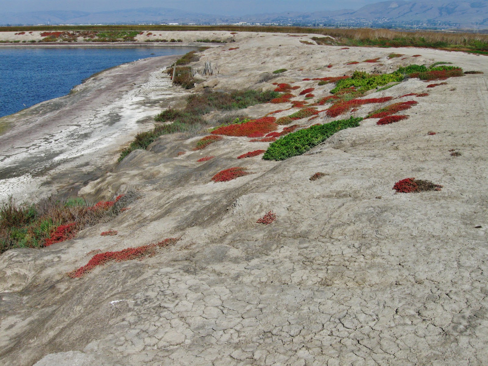
Out beyond this quaint habitat lie miles of austere salt ponds waiting their turn for rebirth. Berms of dredged earth between the ponds allow safe passage across the divided landscape. Adding to the surreality of the whole scene is the fact that an Amtrak line passes right through the middle of the refuge. Because of the flat topography, you don’t even become aware of this fact until you happen upon the tracks or see a train jetting by in the distance. This refuge is in the early stages of undergoing a 16,000 acre restoration, one of the largest and most ambitious to ever be undertaken. A delicate balancing act is required during this process, because while the historic marshes were beneficial for certain species, the current “unnatural” landscape is a boon to others. Natural shallow open water harbors used to exist elsewhere in the bay area to provide a refuge for shorebirds during coastal storms, but now only the salt ponds provide this type of habitat. Some ponds need to remain filled with water in order to ensure that this much needed safe haven continues to exist.

Don Edwards National Wildlife Refuge challenges the idea of what is beautiful, natural and best for all species. Is a natural place more or less beautiful because it exists in tandem with an urban environment? If an artificially created landscape provides a safe port in the storm for wildlife, does that now make it natural? If the train bisecting the refuge allows people to reduce their carbon footprint by using public transport, is it indirectly best for the refuge to keep it running? Perhaps what is most unique about this place is its ability to challenge our perceptions, help us clarify what we value, and guide how we go forward from a century of human-centered progress into an era of development in partnership with the natural world.

Sunday, September 11, 2011

No Easy Answers

I have this book of daily meditations called The Celtic Spirit, by CaitlĂ­n Matthews, that I picked up from my local thrift store one day and I’ve found it to be pretty instructive and inspiring at times. On occasion, I’ve marveled at how accurate a specific day's meditation was to my own life, but this morning’s entry for September 11th, left me speechless…

Cutting Through the Celtic Twilight 

Facks are chiels that winna ding. [Facts are things that cannot be shifted.] - Scots proverb

The reappreciation of the Celtic tradition in the nineteenth century led to an overly romantic view known as the “Celtic twilight”. Professor J.R.R. Tolkien once remarked that “anything is possible in the fabulous Celtic twilight, which is not so much a twilight of the gods as of the reason.” It is a very dangerous place to inhabit, this twilight, as the poet W.B. Yeats discovered; he, who had himself been instrumental in the formation of that twilight, hit the hard iron of reality during the savage Irish civil war, writing in “The Stare’s Nest by My Window”:

We had fed the heart on fantasies,
The heart’s grown brutal from the fare,
More substance in our enmities
Than in our love.

Many of the popular myths and fantasies that have been woven around the Celts – some self-fabricated – have been designed largely to mantle the unpalatable facts of conquest, colonization, and cultural diminishment. Romantic traditions are tales that both colonizers and the colonized have spun after the event. The living, transformative myths are those that speak to us in all eras and conditions. But the minute we listen to romantic traditions, with their victimhood and inadequacy thinly veiled by bombast and boast, we mire in a quicksand that will suck us out of reality into a jealous cauldron where bitter nationalism and retributive terrorism can be brewed.

Take a hard look at the romantic traditions concerning your own people. What enemies to the common good are lurking behind them?
_________________________________________________

The book was published in 1999. At first, I didn't want to share this meditation in a public forum, because the mix of emotions and thoughts is complicated enough today, but ideas related to this meditation swirled and coalesced in my mind. I appreciate how it weaves a thread through many thoughts and ideas I’ve been mulling over and discussing with friends and family the past few months - injustice, tradition, culture, romanticism, nostalgia, myth, reality. In the past I might have found the message disheartening in its timelessness, but today it feels sobering and contemplative. Because of understanding gained through conversations with others, I have a new awareness of the tug between emotion and intellect in my mind when thinking about the complicated themes associated with September 11th, and the chain of events in the decade that followed. Perhaps when answers are hard to come by that awareness is enough.

For me the hardest part is still discerning between romanticism and reality, while quelling the judgment in my heart for those who feel and think differently than me. This is a challenge for all time, for all people across all situations. While we must seek to understand and learn, perhaps it is only with an awareness of our romantic human tendencies that we might rise above to discover those “living, transformative myths” – the shared truths that connect us, as well as those that divide.

Wednesday, August 31, 2011

The August River

The river behind our house is a reflection of the seasons. In the fall and winter, its flows fluctuate with the rain and then ebb with the snow. The moisture remains locked up within the frozen high mountains until the warmth of spring returns. Thin ribbons of melting water descend and merge along the length of the mountain until finally they converge, turning the river into a roaring torrent.

The Kaweah River is an altogether different body of water in the late summer season. As the weeks pass, it flows gently through the valley with ever decreasing velocity and volume, creating a serene oasis of cool moisture in the hot, dry foothills. Aside from an unusual pulse of tropical moisture which pushed its way up into the central Sierra for one day at the end of July, the mountains have not seen a drop of precipitation since late May. All but the last remaining patches of stubborn snow have melted in the high Sierra, feeding the river with scant trickles of moisture.

The gradient of the riverbed is more perceptible now that the level is lower, turning torrid rapids into steps and terraces which create a cascading effect. The resulting white froth contrasts sharply with the earth toned rocks obscured just under the surface. Paths of safe passage out into and across the river emerge as the shallow water allows increased visibility of rocks both above and below.

 The rounded angles of the boulders create all manner of seats and perches for experiencing the flow of the water. Although cold to the touch at first, it takes only a minute to recognize the temperature as refreshing rather than freezing. Sitting on a boulder above the water, flecks of cool spray periodically jump up to dot my back and legs. Fingers outstretched with palms upstream I feel the buffeting current thread through my fingers.

One of last year’s sycamore leaves long since dried and curled, is dislodged from its limb by the breeze and descends, gently landing onto the surface of the river. Its golden orange color is similar to the patch of rocks in the water below. I watch it bob and shift with the current, navigating the ripples for a while before tipping and plunging under the water. It moves swiftly now with the flowing water in the direction I expect it to go until suddenly it veers sharply with a much stronger current. I follow it just a little further before it gets sucked into an eddy amongst the boulders and I lose sight of it altogether. My gaze returns to the bed of the river and I notice that it is a patchwork of yellow, cream, dark gray, reddish brown and tan interlaced with and covered by clear greenish blue water. Looking upstream the rounded granite boulders are awash in sunshine, suspended in a plain of undulating glass.

The golden summer season will linger for many more weeks, but in spite of the scorching direct sun and brittle blanket of spent vegetation covering the ground, the days are somehow sweeter this time of year because of the knowledge that they will not last. Long to-do lists and a hurried pace are not compatible with this time of year. Better to make a priority of finding some time to take a dip in the river or rest in a cool patch of shade along its banks. Flowing water demands alignment, which is easy to realize when dangling a foot in the water. Kept toes pointed up or down stream, it’s possible to achieve relative stability and balance, but the moment your foot turns broadside to the current, the river exerts its force. Observing the river, I’m reminded of the peace that comes with slowing down and the awareness that even subdued pressure can realign obstacles.

Sunday, July 24, 2011

One Day in Yosemite Valley

The view from above Yosemite Valley as you come out of the Wawona Tunnel is stunning. I mean take your breath away, jaw droppingly stunning. So much so, that all I could do was sit there on the edge of that stone wall and stare at the expanse of trees, shining granite monoliths and ribbon-like waterfalls that appeared before me. It felt like being in a dream, or getting a momentary glimpse of heaven, but each time I blinked it was still there in front my eyes. While it may seem like a dream from a distance, actually being in Yosemite Valley is very much a call to reality. A place this beautiful can’t help but become an international tourist destination, and so it has precariously taken on that role with a mix of grace and strain.

Yosemite Valley is a treat for all the senses. Verdant green meadows carpet the valley floor, making the contrast between the vivid blue sky and stark white granite domes all the more brilliant. Prior to park service development, the leisurely Merced River flowed freely and replenished the lush meadows by occasionally flooding. To reduce the potential for flooding, provide dry ground for camping and decrease mosquito populations, the river was forced into a more predictable pattern of flow and some of the meadows were drained during the first years of park development. Such changes cut off life sustaining water to these valley jewels and in recent decades, attempts have been made to reinstate more natural processes. Meadow drainage tiles have been removed and where possible, the river is being unbound and allowed to flow as it prefers. Boardwalks throughout the valley now intersect this reinvigorated ecosystem, allowing visitors to wander through the sea of green and more closely observe the scattered wildflowers, wetland birds and grazing mammals that live there.

Waterfalls in the springtime roar inescapably throughout the valley, booming and reverberating off the surrounding stone walls, making the undulating white columns of water in the distance all the more palpable. Humid sprays of water amplify the smell of the trees and soil near the falls, giving the air a saturated, fresh smell. Thousands of people wander around the Yosemite Falls area with their eyes cast upward in awe, speaking dozens of different languages, gesturing animatedly as they interpret the maps and educational displays that explain the beauty before them. The trail system around the falls recently underwent a major renovation to allow for better flow of visitors and reduce soil erosion resulting from overuse. The wide, paved trails now allow those visitors, both young and old, with less physical mobility to more safely enjoy the forested, boulder strewn landscape, and inspiring vistas.

By afternoon, the initial rush of excitement has mellowed and if you give into it, a growing sense of peaceful wonder will descend upon you. Sunshine washes warmth over every surface, while the cooling alpine breeze chases away discomfort. On the back porch of the historic Ahwahnee Hotel guests and passersby relax, while soaking up the ambiance and grandeur of the park reflected through the structure’s immense stone walls. Providing an interesting juxtaposition between refined civility and the wildness that surrounds it, the hotel was built in 1926 to attract wealthy patrons seeking relaxation and restoration. During WWII park tourist visitation decreased dramatically, but war weary soldiers found still found refuge at the Ahwahnee, which was converted for use as a military retreat. The architects took their design inspiration from the landscape and used locally sourced materials to increase the sense that this place is a part of, rather than an escape from, the natural wonders of valley.

Pensive photographers of all ages raise their cameras to frame shots, while plein air painters place their brushes with care in an attempt to capture a moment that will remind them when they return home, that this surreal place really does exist. Rock climbers laden with coils of rope, their steps accented by the clink of hardware on their belt, scramble over boulder piles leading to the base of El Capitan, Half Dome and dozens of other lesser known climbing walls for the thrill of merging with the geologic wonders of the valley. Thousands of cars squeeze into every available parking space, and in the afternoon fellow tourists on foot and bicycle shake their heads in amazement at the bumper to bumper traffic snaking slowly back home during the afternoon rush hour. If you are looking for solitude, this is not the place for you. If you want to see nature untouched by significant human development, there are plenty of other places in the Sierra Nevada to visit. But if you are looking for natural beauty of the kind rarely seen with such ease, and the communal experience of marveling at that beauty with so many other people from across the country and around the globe, then Yosemite Valley is a place you should experience for yourself.

Friday, May 13, 2011

Changing Seasons

After six months of verdant green, the valley is shifting into the dry golden summer season, so I took a drive this morning to document some of the changes taking place.

The olive groves are in "bloom" right now, which may not appear very spectacular from the highway, but close up the flowers have their own unique beauty.

Winter citrus have been forgotten for the moment, now that we've all eaten our fill and moved on to strawberries and cherries.

But the farmers haven't completely forgotten about them. Spring is a good time to trim up the trees so they're primed for picking again next winter.

Pomegranate bushes happen to have a lot in common with the olive trees. Both are ancient fruits that have been cultivated for thousands of years around the Mediterranean, in a climate very similar to the central valley of California.

Where the olive tree flowers may lack in traditional beauty, the pomegranate blossoms more than make up for it.

Lake Kaweah is on the rise as ample snowpack from the Sierra melts and runs down into the rivers and streams that feed into it. The trees that are slowly being submerged will reappear in the fall as water is used by farmers in the valley for irrigation and the lake level drops. Shortly thereafter, new leaves will appear on the trees as if nothing had ever happened.

Even as everything is drying up, there are still flowers to be found.

This flower's common name happens to be "Farewell to spring". What this says about the discoverer's opinion of the arrival of summer I'm not sure, but it certainly is nice to have such a profusion of beautiful flowers to usher in the season.

I ended my trip at the Sierra Garden Center where I bought a few drought tolerant herbs for the porch. I know from personal experience now that it's going to be a long dry summer, so a little bit of green by the front door will go a long way!

Wednesday, April 27, 2011

A Day in the Life of a Physical Science Technician

Those of you who have known me for a while, are probably aware that I've had a number of different careers in my life up to this point. High school science teacher, special education teaching assistant, non-profit administrative assistant and program manager, community college counselor and program director. Upon moving to Three Rivers, the parade of jobs was sure to continue and everyone, myself included, was pretty curious to know what I would do next for a living.

I started off working as a biological science technician, running around off trail in the forest helping to collect plant and tree data for the park Fire Ecology program. Little did I know that waiting in the wings was an opportunity to finally use my Bachelor's degree in Meteorology, which I earned thirteen (!) years ago and considered only as a brief step on the path toward my Masters in Education.

I am now officially a Physical Science Technician at Sequoia and Kings Canyon National Park. Sounds like a pretty interesting job, doesn't it? But what does it actually mean? I've gotten that question a fair bit and the short answer is that I now run around the park collecting air, weather and precipitation data for the Air Resources program. The long answer is a bit more or less interesting, depending on how much of a nerd you are.

I mentioned in my very first blog post that Seqouia and Kings Canyon National Parks have some of the worst air quality in the nation, because of their location just east of the San Joaquin Valley, which traps pollution from agricultural practices as well as car exhaust from the Bay Area and the valley. It's a bad combination that leads to significant ozone and particulate matter accumulating in the air. Both are health hazards and obscure visibility by filling the air with a brownish gray haze. I suppose I could now also look at them as a form of job security.

The park has two air monitoring sites - one down near the headquarters at Ash Mountain (elev 1,000 ft) and another up in the Giant Forest (elev 7,500 ft). The Ash Mountain site focuses primarily on monitoring ozone and particulate matter (tiny little specks 2.5-10 microns in diameter that get into your lungs with unpleasant health impacts). Numerous pieces of equipment with different types of filters are running twenty-four hours a day, all year long analyzing the air for ozone, ammonia, particulate matter and other hazardous gases and pollutants. The Giant Forest site looks much more at pollution in the precipitation that falls as rain or snow at elevation. The precipitation samples collected are primarily analyzed for the various components of acid rain, mercury, and now because of the nuclear situation in Japan, radiation.

By far, the best part of my job has been snowshoeing the quarter mile into the Giant Forest site every Tuesday. Sites need to be located in a place where trees don't interfere with the collectors, so in the Giant Forest that meant finding a patch of relatively level ground on the edge of the mountain. I would be quite content doing the most boring job in the world (for a while, anyway), as long as I had this view and got to take this walk through the trees once a week.


View of the valley from the Giant Forest site


Sunlight through the clouds


The day after a snowstorm

Thankfully, this job happens to also involve doing a lot of really interesting things. Collecting precipitation requires a fair amount of vigilance and precision to avoid contaminating the sample. Gathering the data and keeping all the equipment running involves knowing a little about a lot - technology, electronics, basic home repair, common sense, and communication skills, because if anything (including the building that houses all the electronics) breaks it's up to us technicians to fix it with phone support from the various research labs around the country who receive and analyze our data and samples. This week for example, I learned how to replace the diaphragm on an ozone analyzer.


Electronics equipment inside the shelter


Belfort rain gauge (I'll be sad to see this relic go!)


Me cleaning the Mercury Deposition Network precipitation collector

In addition to working for Air Resources, I have also assisted with a database management project for the Environmental Compliance division and the research permit database for the Resource Division. Even the office jobs in the National Park Service are pretty darn interesting. All those years ago at Purdue, I would have never believed that one day I'd be using my degree in this way. It just goes to show that you never know where life is going to take you, but if you're open to the possibilities all kinds of adventures are waiting!

Wednesday, March 30, 2011

The Big Island: Part II

Finally, my long overdue second installment of our trip to the Big Island of Hawai’i in November (yes, five months later, I know). When we last left off, Peter and I were staying in Volcano, just five minutes outside Hawai’i Volcanoes National Park. Upon leaving Volcano, we continued driving north around the island to head back to Kona...

Forty five minutes north of Volcano is Hilo, the capital of the islands. It’s a beautiful sprawling city full of pastel houses and tropical flowers, situated right along the ocean. Much of Hilo was destroyed in a tsunami in 1960, sparing only a few of the downtown buildings, so its history and character seem to be scattered in pockets throughout the city. The famous farmer’s market is open almost every day of the week to sell fruits and vegetables from equatorial regions around the globe. A stroll around downtown reveals occasional glimpses of the "real" Hawai'i where local residents live and work, and tourists just pass through. We stopped by Hilo Shark's Coffee Shop on Waianuenue Avenue a few times to fill up on Kona coffee in the morning and lilikoi lemonade in the afternoon. Another pleasant surprise was the Papahanaumokuakea Marine National Monument Discovery Center, which is a great free visitor center that introduces people to the importance of a marine sanctuary so remote and protected that few people will ever see it.


Just north of Hilo is the spectacular Hawai'i Tropical Botanical Gardens, a privately owned garden preserve located in a verdent valley right on the ocean. The paved trails wind through shady groves of tropical plants from all around the world. You might feel a little like Alice in Wonderland as you try to comprehend the outrageous forms and colors fighting for your attention. We spent a whole afternoon wandering around the grounds taking one picture after another. My favorite spot was the orchid garden, with flowers so beautiful it seemed impossible that they were real. North of the gardens is What's Shakin', a little open air cafe in the rolling hills with a view of the ocean. They make great fruit smooties, sandwiches and salads that might cost more than you'd pay in Hilo, but the setting and freshness of the food can't be beat.


Continuing north along the winding highway is the Hawai'i of your dreams. Towering green mountains, cascading waterfalls and steep-sided lush valleys wait around every turn. If you have the time, you should definitely check out Akaka Falls State Park for a pleasant hike through a mountain rainforest that leads to a 400 foot waterfall. For the minimal effort it takes to walk the smoothly paved trail, you get an incredible view of one of the most stunning ribbon falls on the island. It's worth the drive. Before you get back on the highway, you might enjoy taking a little stroll around the village of Honomu, which was a thriving mill town back in the early to mid-20th century, when sugar dominated the island economy. This portion of the highway ends at the overlook into Waipi'o Valley, a place that is sacred to native Hawai'ians. The road down into the valley is only accessible by 4-wheel drive vehicles, and at an average grade of 25%, if it were actually classified as a road it would be one of the steepest in the world.


From Waipi'o Valley, you head west and up into the high country of Waimea. This ranching community has a distinct western charm, with grazing livestock dotting the rolling green hills. Coming down the western mountain slopes, the green quickly fades away to a desert of rock and cactus, and just beyond, the blue ocean. It's a strange combination and one that feels particularly barren after the lushness of the drive from Hilo. Pu'ukohola Heiau National Historic Site sits right on the ocean just down the mountain from Waimea. This side of the island is very hot and often windy, so a visit to this site is only recommended if you have a strong interest in knowing more about the complicated history of the Hawai'ian people. I learned a lot, but was also feeling pretty worn out by this point.


With a few hours to spare before our flight and not enough energy to sightsee in the heat, what else was there to do, but crash the bar at the Four Seasons north of Kona? While the rest of the coast was whipped into a frenzy by strong winds, the beach at the Four Seasons was blissfully calm. We walked along the beach watching the rolling turquoise waves and stalked some of the non-native flightless fowl begging for handouts around the bar area, before settling down into plush deck chairs to have ridiculously over priced drinks and appetizers. After a busy four days traveling all over the island, the chance to sit in a comfortable chair, sip a cold glass of white wine, and watch the sun set over the Pacific Ocean was worth every penny.