Wednesday, April 27, 2011

A Day in the Life of a Physical Science Technician

Those of you who have known me for a while, are probably aware that I've had a number of different careers in my life up to this point. High school science teacher, special education teaching assistant, non-profit administrative assistant and program manager, community college counselor and program director. Upon moving to Three Rivers, the parade of jobs was sure to continue and everyone, myself included, was pretty curious to know what I would do next for a living.

I started off working as a biological science technician, running around off trail in the forest helping to collect plant and tree data for the park Fire Ecology program. Little did I know that waiting in the wings was an opportunity to finally use my Bachelor's degree in Meteorology, which I earned thirteen (!) years ago and considered only as a brief step on the path toward my Masters in Education.

I am now officially a Physical Science Technician at Sequoia and Kings Canyon National Park. Sounds like a pretty interesting job, doesn't it? But what does it actually mean? I've gotten that question a fair bit and the short answer is that I now run around the park collecting air, weather and precipitation data for the Air Resources program. The long answer is a bit more or less interesting, depending on how much of a nerd you are.

I mentioned in my very first blog post that Seqouia and Kings Canyon National Parks have some of the worst air quality in the nation, because of their location just east of the San Joaquin Valley, which traps pollution from agricultural practices as well as car exhaust from the Bay Area and the valley. It's a bad combination that leads to significant ozone and particulate matter accumulating in the air. Both are health hazards and obscure visibility by filling the air with a brownish gray haze. I suppose I could now also look at them as a form of job security.

The park has two air monitoring sites - one down near the headquarters at Ash Mountain (elev 1,000 ft) and another up in the Giant Forest (elev 7,500 ft). The Ash Mountain site focuses primarily on monitoring ozone and particulate matter (tiny little specks 2.5-10 microns in diameter that get into your lungs with unpleasant health impacts). Numerous pieces of equipment with different types of filters are running twenty-four hours a day, all year long analyzing the air for ozone, ammonia, particulate matter and other hazardous gases and pollutants. The Giant Forest site looks much more at pollution in the precipitation that falls as rain or snow at elevation. The precipitation samples collected are primarily analyzed for the various components of acid rain, mercury, and now because of the nuclear situation in Japan, radiation.

By far, the best part of my job has been snowshoeing the quarter mile into the Giant Forest site every Tuesday. Sites need to be located in a place where trees don't interfere with the collectors, so in the Giant Forest that meant finding a patch of relatively level ground on the edge of the mountain. I would be quite content doing the most boring job in the world (for a while, anyway), as long as I had this view and got to take this walk through the trees once a week.


View of the valley from the Giant Forest site


Sunlight through the clouds


The day after a snowstorm

Thankfully, this job happens to also involve doing a lot of really interesting things. Collecting precipitation requires a fair amount of vigilance and precision to avoid contaminating the sample. Gathering the data and keeping all the equipment running involves knowing a little about a lot - technology, electronics, basic home repair, common sense, and communication skills, because if anything (including the building that houses all the electronics) breaks it's up to us technicians to fix it with phone support from the various research labs around the country who receive and analyze our data and samples. This week for example, I learned how to replace the diaphragm on an ozone analyzer.


Electronics equipment inside the shelter


Belfort rain gauge (I'll be sad to see this relic go!)


Me cleaning the Mercury Deposition Network precipitation collector

In addition to working for Air Resources, I have also assisted with a database management project for the Environmental Compliance division and the research permit database for the Resource Division. Even the office jobs in the National Park Service are pretty darn interesting. All those years ago at Purdue, I would have never believed that one day I'd be using my degree in this way. It just goes to show that you never know where life is going to take you, but if you're open to the possibilities all kinds of adventures are waiting!

Wednesday, March 30, 2011

The Big Island: Part II

Finally, my long overdue second installment of our trip to the Big Island of Hawai’i in November (yes, five months later, I know). When we last left off, Peter and I were staying in Volcano, just five minutes outside Hawai’i Volcanoes National Park. Upon leaving Volcano, we continued driving north around the island to head back to Kona...

Forty five minutes north of Volcano is Hilo, the capital of the islands. It’s a beautiful sprawling city full of pastel houses and tropical flowers, situated right along the ocean. Much of Hilo was destroyed in a tsunami in 1960, sparing only a few of the downtown buildings, so its history and character seem to be scattered in pockets throughout the city. The famous farmer’s market is open almost every day of the week to sell fruits and vegetables from equatorial regions around the globe. A stroll around downtown reveals occasional glimpses of the "real" Hawai'i where local residents live and work, and tourists just pass through. We stopped by Hilo Shark's Coffee Shop on Waianuenue Avenue a few times to fill up on Kona coffee in the morning and lilikoi lemonade in the afternoon. Another pleasant surprise was the Papahanaumokuakea Marine National Monument Discovery Center, which is a great free visitor center that introduces people to the importance of a marine sanctuary so remote and protected that few people will ever see it.


Just north of Hilo is the spectacular Hawai'i Tropical Botanical Gardens, a privately owned garden preserve located in a verdent valley right on the ocean. The paved trails wind through shady groves of tropical plants from all around the world. You might feel a little like Alice in Wonderland as you try to comprehend the outrageous forms and colors fighting for your attention. We spent a whole afternoon wandering around the grounds taking one picture after another. My favorite spot was the orchid garden, with flowers so beautiful it seemed impossible that they were real. North of the gardens is What's Shakin', a little open air cafe in the rolling hills with a view of the ocean. They make great fruit smooties, sandwiches and salads that might cost more than you'd pay in Hilo, but the setting and freshness of the food can't be beat.


Continuing north along the winding highway is the Hawai'i of your dreams. Towering green mountains, cascading waterfalls and steep-sided lush valleys wait around every turn. If you have the time, you should definitely check out Akaka Falls State Park for a pleasant hike through a mountain rainforest that leads to a 400 foot waterfall. For the minimal effort it takes to walk the smoothly paved trail, you get an incredible view of one of the most stunning ribbon falls on the island. It's worth the drive. Before you get back on the highway, you might enjoy taking a little stroll around the village of Honomu, which was a thriving mill town back in the early to mid-20th century, when sugar dominated the island economy. This portion of the highway ends at the overlook into Waipi'o Valley, a place that is sacred to native Hawai'ians. The road down into the valley is only accessible by 4-wheel drive vehicles, and at an average grade of 25%, if it were actually classified as a road it would be one of the steepest in the world.


From Waipi'o Valley, you head west and up into the high country of Waimea. This ranching community has a distinct western charm, with grazing livestock dotting the rolling green hills. Coming down the western mountain slopes, the green quickly fades away to a desert of rock and cactus, and just beyond, the blue ocean. It's a strange combination and one that feels particularly barren after the lushness of the drive from Hilo. Pu'ukohola Heiau National Historic Site sits right on the ocean just down the mountain from Waimea. This side of the island is very hot and often windy, so a visit to this site is only recommended if you have a strong interest in knowing more about the complicated history of the Hawai'ian people. I learned a lot, but was also feeling pretty worn out by this point.


With a few hours to spare before our flight and not enough energy to sightsee in the heat, what else was there to do, but crash the bar at the Four Seasons north of Kona? While the rest of the coast was whipped into a frenzy by strong winds, the beach at the Four Seasons was blissfully calm. We walked along the beach watching the rolling turquoise waves and stalked some of the non-native flightless fowl begging for handouts around the bar area, before settling down into plush deck chairs to have ridiculously over priced drinks and appetizers. After a busy four days traveling all over the island, the chance to sit in a comfortable chair, sip a cold glass of white wine, and watch the sun set over the Pacific Ocean was worth every penny.

Tuesday, March 22, 2011

Death Valley Adventures

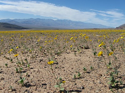
Coming down out of the mountains into Death Valley on Hwy 178, the wide expanse of white salt flats reflect blindingly in the sunshine. Spring wildflowers line the roadsides and fields of flowers light up the seemingly lifeless rocky ground. Telescope Peak towers more than 12,000 feet above Badwater Basin, the lowest point in North America. Massive inclined plains of jumbled rock fan out at the mouth of each canyon. Everything seems larger than life and then you get out of the car to take a photo and have to catch yourself before you step on a delicate stem of wildflowers. You quickly get the feeling you could spend a lifetime in this extraordinary place and still never fully know it.

Precious water flows up from the ground and breathes life into this arid desert at Salt Creek. The endangered Death Valley Pupfish have adapted over the last 10,000 years to tolerate an ever dwindling body of water which is two to three times saltier than the ocean. The fish burrow into the mud and hibernate through the cold winter, breed in the early spring and then attempt to survive through the summer and fall as evaporating creek pools grow smaller and more saline. Most don't survive. That any of them could in a place where water temperatures regularly reach 112 degrees in the summer is a testament to the persistence of life.

For all its harsh extremes, the valley became a haven from city life for a Chicago couple named Albert and Bessilyn Johnson. Albert came to know and love the desert through his adventurous camping trips with an eccentric local character named Death Valley Scotty. His wife, on the other hand, wanted a much more civilized desert experience, so in 1922 they began building their dream vacation home in the style of an ancient Spanish castle. The extravagant refuge took more than ten years to build and spared no expense with the finest handcrafted construction.

In spite of her desire for opulence and comfort, Bessilyn fell in love with the simplicity of the desert once writing that, "Something about the clear desert atmosphere seems to make the moonlight brighter than anywhere else in the world, and to glorify it. And the great mountains rise in the splendor of it all. Moonlight in the Desert! You may have cities and electric lights, movies, dancing parties, and surging crowds; but for a thrill, an emotion, a sense of peace, and a confidence in a God who cares, give me moonlight in the Desert."

I may never feel a strong pull to return to Death Valley, but I can understand why some people do again and again, as each of us know the places that speak to our heart. What I will always remember are the surreal moments of beauty that you can only find in that valley. Experiencing complete silence in the middle of the white salt flats while watching the clouds and mountains turn pink at sunrise, seeing the unearthly topography of Devil's Golf Course stretching out to the horizon, and sleeping outside under a near full moon in the sand dunes on my birthday, feeling that same sense of peace that Bessilyn Johnson described.

Here are a few other photographic memories from our trip:


Sunrise at Mesquite Flats sand dunes

Stovepipe Wells campground by moonlight


Devil's Golf Course

Desert gold off Hwy 178 in mid-March

Monday, February 14, 2011

Marble Falls Early Spring Hike

Early spring has arrived in the foothills! The daffodils are up, all the California buckeye have leafed out, and the other trees and shrubs are in various stages of bud and bloom. Even though it never gets cold enough here for me to have any real complaints, it hasn't actually felt like spring until this past weekend. A dry cold front moved through earlier in the week, sweeping the stagnant haze out of the valley and temperatures finally cracked the 70 degree mark, making it a warm and blissfully clear Saturday to go for a hike.

The last time we hiked Marble Falls was in June - the very first hike we went on after moving here. I was curious to see how different the trail would look in the very early stages of spring. There are no wildflowers in bloom yet, but still a variety of interesting signs of plant life to be seen.


The trail switchbacks up the side of the mountain, following the stream-eroded topography, which means you weave in and out of exposed, hot dry chaparral and cool, damp green canyons. There are so many contrasts between these two habitats, which exist side-by-side: hot and cool, dry and damp, bare rock and moss, dust and streams.


Once you get higher up the mountain, you round a corner and finally see the entrance to the deepest part of Marble Canyon. The size, number and variety of trees increases with the cooler temperatures and greater moisture at higher elevation. The angle of the mountainside causes many of the trees to arch with the pull of gravity as they reach for sunlight. California bay laurel trees also become more plentiful and their leaves and flowers fill the air with a fresh sweet smell that makes you wish you could bottle up to take with you after you leave. The sound of the falls grows louder as you get closer. As my husband commented, hiking this trail really is an experience that makes all your senses ridiculously happy.


By the time you reach the falls you are walking on a floor of undulating gray and white banded marble, resulting from metamorphosed limestone during the formation of the mountains, and smoothed by countless years of flowing water. The contrast between the white rock and the shadow cast by the canyon wall is so great that it's difficult to take good pictures of the falls themselves. That being said, it's still a great place to take interesting pictures, and especially to sit and enjoy the powerful rush of water.


We hope to hike this trail again sometime in April to see how it evolves as spring continues. I'll be sure to post pictures of that hike so you can see the changes! If you'd like to see more pictures from this hike, you can view them here.

Since my last post, I've started working for the park as a Physical Science Technician doing data collection and instrument maintenance for the Air Resources program at the park. Once I take a few more photos, I'll be sure to post about that experience in more detail. I also owe you two more posts on our vacation to Hawai'i, which I'm sure I'll be happy to revisit as the rain and cold return to Three Rivers this week.

Friday, December 3, 2010

Big Island Highlights Pt. I

It’s definitely colder during the winter here in Three Rivers than it was in Carlsbad, or maybe it’s just the drafty 70 year old house we’re living in. Not that I’m complaining, mind you. While there’s about four feet of snow up in the Giant Forest now, there’s none in our yard and isn’t likely to be any all winter long. But, it has rained almost four inches since October and it’s definitely more humid, because the clothes out on the line don’t dry near as quickly. As everyone says about damp cold – it chills you straight to the bone. Unlike the southwest, which gets monsoon rains, it’s dry with hardly a cloud in the sky here in the central valley and foothills of California all summer long. Sometime in October a switch flips and all the sudden we start getting cloudy days with rain. That rain falls as lots of snow up on the mountains, but unlike the powdery quality of the Rocky Mountains, Sierra snow is more commonly referred to as “cement” due to the high moisture content. I marvel at the influence the ocean currents have on our weather here, that it can create such dramatic differences between summer and winter.

But enough about all this cold weather, rain, and snow. What better time to revisit fond memories of balmy Hawai’i? Our friends Julie and Brian accepted jobs at Haleakala National Park back in February. After we moved to California, a trip to Hawai’i quickly moved up our priority list. Flying to Hawai’i is no small feat. It’s the most remote island chain on the plant, so flight time from LA is about five hours with a two to three hour time change, depending on the time of year (Hawai’i doesn’t observe daylight savings time). I greatly admire those Midwesterners and East Coast residents who make the trip, because the jet lag can be significant. Given that it takes so long to get there and the fact that I’ve got a lot of time off right now, we decided to go for two weeks and add on a trip to the Big Island.

My first trip to Hawai’i was over eight years ago, when I went with my friends Jen and Brian to Oahu and Mau’i. Jen and Brian have since returned MANY times to the islands and had lots of wonderful suggestions for places to go and things to do on the Big Island, which is confusingly named Hawai’i, the same name obviously given to the entire grouping of islands, hence the need to refer to the island of Hawai’i as the Big Island. We took a 45 minute flight from Mau’i to the town of Kona in a very tiny nine-seat commuter plane and then drove the southern route over to Volcano (~100 miles), making lots of stops along the way. We went to Kaloko-Honokohau National Historic Park in the Kailua-Kona area, which is a small park preserving the traditional fish farming techniques of the native Hawai’ians. There’s a short walking trail between the park and the boat marina to the south, which leads to a beautiful little beach edged with palm trees where you can see the walls of the fish ponds sticking up above the turquoise blue ocean water. You take a swim and watch green sea turtles hunting for small fish right off shore. We also had a fabulous meal at Thai Orchid Cuisine in the industrial/shopping district south of the park (Jen also recommended Killer Taco, which we searched for, but of course we only found it after we had settled on the Thai restaurant. Thankfully, the disappointment factor was low.)


Further south, you come to Pu’uhonua o Honaunau , Place of Refuge, another national historic park. This was a religious compound for the highest members of Hawai’ian royalty, and also a place where individuals in trouble could seek protection and forgiveness for laws they had broken. The park is in sight of a crowded snorkeling beach just to the north and to the south is the wild, undeveloped coastline, but in this place under the graceful palm trees, you are overcome with a tangible sense of peace and stability. We so enjoyed the afternoon we spent in the park and would highly recommend it to anyone looking for an opportunity to learn more about the ancient Hawai’ian people.

As you continue south on the main highway, keep an eye out for the South Kona Fruit Stand . Jen recommended this place for its fresh passion fruit lemonade and she was so right! They sell a wide variety of tropical fruits grown on their property up the hill from the stand and also provide a tempting array of homemade tropical drinks, smoothies and desserts. You should definitely check it out!

As you continue down around the south side of the island, you see fewer and fewer towns. This is truly a wild and undeveloped place by Hawai’i standards. If you’re looking for Hawai’ian coffee, take a chance and stop at one of the small farm stands along the way. We decided to stop at Ailani Orchard to sample their organic coffee and macadamia nuts. If you go, be sure to watch out for the free roaming turkeys on the property, as they seem to feel very strongly that they have the right-of-way. This is not the verdant, mountainous coastline of your Hawai’ian dreams. One lava flow after another has coated this area in thick black pahoe’hoe and ‘a’a, which are the two main types of volcanic rock on the island. New life quickly takes hold in those lava flows and you will see trees and other vegetation slowly beginning to take back the land.

Hawai’i Volcanoes National Park is the number one tourist destination in the state for very good reason. Here you have an opportunity to look through a window into the underworld and see powerful geologic forces in action, any time of day or night. Kilauea Crater is currently the most active volcano on the island. In 2008 a new vent opened up in Halema’uma’u Crater, which leads directly to a large pool of magma below. Throughout the day you can see the plume of steam and noxious gases being emitted from the vent, but the real show is at night. Light from the orange molten lava reflects off the plume, giving the entire vent an eerie glow, easily visible from the Jaggar Museum overlook. The plume acts as a mirror, reflecting a world rarely visible on the earth’s surface. Although the surface lava flows have been greatly reduced in recent months, you can still also see lava pouring directly into the ocean on county land outside the park. We opted out of this adventure, due to lack of time and necessary equipment. You should take at least two flashlights with you if you go to observe the lava flow at dusk and a pair of protective gloves would be a good idea as well, because ‘a’a is sharp as glass, should you trip while walking over uneven ground in the dark to get back to your car. We weren’t completely disappointed, because you can see the steam plume from the far southern part of the park. To know that I was in sight of new land being created at that very moment was thrill enough for me…for now.

The sleepy artist colony of Volcano is just a five minute drive from the park. If you decide to stay, plan your meals ahead of time and stock up on provisions in Kona or Hilo before you arrive. The town does cater to tourists, but it doesn’t bend over backward for them. Few restaurants are open for dinner and many have limited daytime hours. We found some good salads and soups at CafĂ© O’hia, but chose to make most of our dinners at our hostel using produce we purchased from the Hilo farmer’s market. We stayed at the Holo Holo Inn , which provides dormitory and private accommodations for a very reasonable price. Our private room with a shared bathroom was just $56/night. Because it was the off-season, I actually never had to share the bathroom and we had total access to their hostel kitchen, which was stocked with everything you could need, including beautiful dishware made from a local pottery artist.

In my next installment, I’ll give details on our time spent in the Hilo area and talk about the sights to see on the northern route back to Kona. As for now, I need to wrap up so I can finish packing before my trip to Chicago tomorrow. I’ll be home for ten days to visit family and friends, and then return to Three Rivers for a bit before heading to Minneapolis for Christmas. I hope you all are enjoying the joyous holiday season!

Wednesday, October 27, 2010

I'm Back!


Whew, that was close! I ALMOST abandoned another blogging effort. It’s the same thing every time. I start off with lots of motivation and energy, posting on a regular basis and enjoying the feedback and interaction I get with all of you. And then, I start to slack off. I tell myself I have every intention of posting soon and then I keep telling myself that until, ack! How did two months go by? At that point, I start questioning my motivation and stop looking for my energy. It becomes a chore and I just don’t feel like doing it (kind of like the dirty dishes that are staring at me in the sink right now :)).

But, something happened today! I realized that this time, I’ve picked a theme for my blogging that really speaks to my heart. I love being out in nature and living near such beautiful, protected places. I love being able to share this experience with you, my friends and family who are often so far away. Blogging about these experiences seems to multiply the joy. And so today, I’ve rediscovered my motivation and I have the energy to keep plugging away – for another few months any way :).

Our most recent trip was to the eastern side of the Sierra Nevada in the Owens Valley over Labor Day weekend (see, I told you it’s been a long time). We wanted to go somewhere to escape the throngs of vacationing Californians during the holiday weekend, and this turned out to be a good choice. Even though we were only about 50 miles away from our home in Three Rivers, it took us almost five hours to get to the other side of the mountain range! There isn’t a road to get across, so you have to drive down south through Bakersfield or up north through Yosemite to reach the Owens Valley. The small line of towns situated in the valley cater to the tourist who come for a wide variety of outdoor pursuits, from fishing the streams that come down off the mountain, to hiking Mt. Whitney, the highest point in the lower 48 states.

The eastern side of the valley is bordered by the White Mountains. Standing in the middle of the valley your eye is naturally drawn to the more dramatic craggy peaks and tree covered slopes of the Sierra. The White Mountains look lifeless by comparison. Even still, you can’t ignore the fact that it’s a massive mountain range. It turns out that the highest peak in the White Mountains is just 250 feet shy of Mt. Whitney. At the bottom of Owens Valley you are surrounded on both sides by more than 10,000 vertical feet of rock. It’s a humbling experience and one that makes you feel very, very tiny.

Another treasure to be found in the White Mountains is the oldest living tree on Earth. Great Basin Bristlecone pines are found throughout the high mountains of California and Nevada. They can grow to be very large, impressive trees if they receive adequate moisture, but ironically, it’s the trees with the worst soil and least amount of water that live to be almost 5,000 years old. Poor growing conditions make the wood very hard, which in turn makes the trees more resistant to disease and fire. The ancient Bristlecone pines in the White Mountains were saplings when the pyramids were built and full grown trees by the fall of the Roman Empire. They are so gnarled and twisted that some appear to be dead, until you notice a branch with green pine needles sticking out at the top of the tree, as if shaking its fist to the sky in defiance of death.

Every little town in Owens Valley has a forest service road that takes you into the Sierra high country. From there you can camp, fish, hike or just enjoy the scenery and the cool mountain air. A small campground in Onion Valley can be reached by driving east from Independence. The road ends in a glacier carved valley at an elevation of 9,500 feet and is one of the prettiest campsites I’ve ever stayed in. It’s a real luxury to enjoy all the comforts of car camping in a place as beautiful as most backcountry campsites. The campground is managed by the US Forest Service and reservations are strongly recommended.

Peter’s uncle Dan suggested that we visit the Arizona Hills while we were in the area, so we camped there on our last night to take advantage of the morning light in this geologically unique area. There are dozens of granite arches scattered throughout the hills and boulders at the base of the Sierras, one of which perfectly frames Mt. Whitney. The setting is very striking for the difference in color and form between the reddish-brown rounded hills and the triangular gray mountains. Because of its beauty and otherworldly setting, the Arizona Hills have been featured in many movies over the past eighty years, including Gunga Din, How the West Was Won, Star Trek V and VII, as well as Gladiator and Iron Man. The town of Lone Pine celebrates its movie history with a film museum, annual film festival and lots of vintage western charm.

If you want to view more photos from our trip, please check them out here. We wish we had more time to see the sights in the northern part of Owens Valley near Bishop and Mammoth Lakes. There are even more alpine lakes and trails to explore in that area, as well as Mono Lake and the mining ghost town of Bodie. There’s just never enough time to explore all the beautiful parts of this huge state!

On a personal note, I’ve determined that there isn’t much demand in Three Rivers for tutoring or substitute teaching, so I continue to explore my options at the park. In the meantime, I’m using this period as an opportunity to pursue my favorite hobbies and to travel. Peter and I are going to Hawaii for two weeks in early November to visit our friends Julie and Brian. We’ll spend Thanksgiving with my aunt in the Bay area, and then I will be going back to Illinois and Indiana for ten days in mid-December. We’ll finish up the holiday season in Minneapolis with Peter’s family and then in January I’ll survey the scene and decide what to do next. My creative venture is starting to take shape, but I’m still not ready to divulge details. I’ll be sure to do that in my next post, which will be completed shortly after returning from Hawaii. I promise :).

Saturday, August 21, 2010

The Answer to Your Question


For the weeks and months leading up to our move from Carlsbad, I found myself getting asked the same question from people over and over, "What are you going to be doing in Three Rivers?". I found myself at a bit of a loss for words, as I knew that this move was primarily for Peter's job. My prospects were much hazier, since the town is very small and we would be over 30 minutes from the closest large city. I never doubted that this move was the right decision for us, so I just trusted that everything would work out in time.

Eventually, I was put in touch with the park Fire Ecologist regarding an emergency hire biological technician position he was looking to fill. Tony seemed totally on board with hiring me from the very beginning, even with my severe lack of a biology background and little field work experience. I started working for the fire effects crew in mid-July and finally feel like I have enough perspective on the job duties and the experience to share some of the interesting and exceptional opportunities I've had over the past few weeks.

Most of the western United States experiences little rain and frequent dry thunderstorms throughout the summer. Lightning started wildland fires have been occurring for thousands of years here, so it does make sense that the plants and trees would have to find a way to benefit from this radical impact on the landscape. The fire effects crew gathers data from grassland, shrub and forest ecosystems in Sequoia and Kings Canyon National Parks to further the research being done on this interrelationship.

It turns out that Sequoia trees, and in fact most all western evergreen species, are dependent upon fire to survive and thrive. Sequoia seedlings need bare soil to germinate and copious amounts of sunshine to grow, making a post-burn forest the ideal breeding ground for new trees. Mature Sequoias have bark up to two feet thick and are extremely fire resistant. Tree rings also show that in the year following a fire, the trees experience a dramatic increase in growth due to the influx of new minerals and fertilizers from burned plant material.

The crew visits established field research plots throughout the park to gather data on anything that is or ever was alive in the area of interest - and I do mean everything. Trees, shrubs, seedlings, vegetation, downed wood, litter (fallen leaves, etc.) and duff (decomposing fallen plant material) are all measured and recorded in a systematic fashion and then eventually entered into a database to provide researchers and park fire management officials with important information on the effects of fire in the ecosystem. The job of a field biology technician is physically challenging and detail oriented, but the people I work with absolutely love their job and I have a tremendous amount of respect for them and all my other field biology friends out there.


I was very fortunate last week to be working and camping in an area with an active lightning-started fire in progress. The Sheep Creek fire has been burning for almost two months and was only around 800 acres on Tuesday morning when we arrived in Kings Canyon, but by the time we left on Thursday afternoon, it had grown to over 1,800 acres! The fire burned all the way from the mountain top down to the road, making it easy to get a close up view of the fire as it consumed the dead and downed fules in the forest. Up to this point, the idea of fire ecology for me had been only theoretical and hypothetical. To see a 40 foot tall dead tree engulfed in flames less than 50 feet in front of me at night made it all very real, very quickly!

Seeing the flames inch across a patch of litter and duff, or watching the progress of an old fallen log being consumed was like watching Mother Nature take a broom to the forest floor, clearing out the clutter and making way for new growth. She works in mysterious, sometimes very intense ways that we can only begin to understand. That we try and help her along sometimes or play the same game without knowing all the rules is equally admirable and foolhardy of us, but I suppose it's better than attributing the forces of nature to the gods and attempting to stop a fire by sacrificing a goat, or something :).

I must confess that while I've had a wonderful time with all these new experiences and have learned a tremendous amount about a very fascinating subject, this is not the job for me! My strengths are people and understanding the 'big picture', while my coworkers' idea of a good time is dissecting a plant down to its tiniest attributes in order to accurately identify the species. They could (and have) spent hours with an unknown grass species, reading through the vegetative key (ligule, glabrous, spikelet, puberulent, lanceolate...the amount of new vocabulary is astounding!), never actually figuring out what the exact species and still say they had a great time. I'm both mystified and humbled by people who love a job I could never imagine myself doing for more than a few weeks. Kindergarten teachers are one example of this, although most teachers of small children are glad that there are people like me in the world who actually like teaching middle and high school students. To each his or her own, right?

Next week is my last camping trip with the field crew and we'll be up in Grant Grove establishing some new research plots. When I return home, I'll switch to part time data entry and other office work to support the fire effects program, while beginning to explore my options in substitute teaching and tutoring. I'm also hatching a plan for a more creative money making venture, which I'll discuss more in my next post. Until then, I hope you all are doing well and enjoying the dog days of summer!